
Flagship Project CERRO EL PLOMO CENTRAL
Processing Cu-Ag-Pb-Zn-Au polymetallic mineral
within a multi-deposit, regional-scale environment
Cerro el Plomo Exploration and Exploitation Project is the company's flagship project in Chile.

OVERVIEW
The El Plomo project is located in the foothills of the fourth region of Chile, San Lorenzo Mining Sector of Limarí province, Monte Patria commune. It is located 280 km in a straight line north from Santiago and 150 km to the SE from Coquimbo, between the coordinates UTM 319390 E, 6575480 N and 319992.00 E, 6574483.00 N (WGS84)
Considering a geological potential, the project is located in the Northern part of a regional scale mineralized structure that had been exploited intensively in the 80th XX century.
MINING EVIDENCE
The most significant mining evidence of the sector are: Mina Variola (extracted and processed 450,000 tons), Luz de Pilar, Mina Bonita. Moreover, 150 years old ruins of smelting operations and 40 years old trapiche based flotation concentrator had been processing the mineral of Cerro el Plomo in the past.
As the monument to the distant mining past, there are on the top of the Cerro el Plomo an impressive 25,000 tons of ARTISANAL DUMPS, aged 150-200 years, resulting from manual extraction and separation of the mineral, aimed to extract high grade of SILVER grains to smelt the material up there.
All the material from dumps were classified and processed by the HCA team at the 150 km far concentrator, recovered 500 mt of high grade Pb, Ag, Au concentrate which was sold to Trafigura international trader mainly.
PROPERTY
The project is being developed on 5 mining claims (pertenencias mineras) of total area 480 He. All the mining properties are 100% owned by COMPAÑIA MINERA POLIMET, 50% shared by HAVENCARE AMERICAS and 50% by private investors.
HISTORY
The mining history of the region tells that a mining activity was developed in the area between the Carcamo hamlets in the north, passing through San Lorenzo, to the surroundings of the Cogotí river valley in the south, mainly of an artisanal character and was concentrated in regional geological structure known as “Corrida del Plomo” (Flores, 1944; Kaiser, 1947).
That time mining was motivated, at first, by the extractive activity of silver during the 19th century. Then in the middle of the 20th century, according to contingencies related to metal prices, especially copper, the main mining manifestations of the “Corrida del Plomo” have been partially reactivated for the extraction of this resource.
According to the information collected by previous studies, the El Plomo mine would have been exploited intensively until 1891, when the miners were recruited for the revolution of that year. Later, until the middle of the last century, the focus of mining activity was at artisanal scale on the surface levels. According to technical reports, the old operations were carried out in branches of minor veins and along the main vein in a horizontal extension of 300 m. with an approximate depth of 20-30 meters from the terrified portal, located at the top of Cerro El Plomo (Kaiser, 1947)
Archive map of the old mine, Empresa Nacional de Minería Studies, 1945
GEOLOGY
The studied property presents a vein-fault type epigenetic hydrothermal mineral deposit, with polymetallic mineral association, linked to a low sulphidation epithermal system, which is located locally in a structural corridor of preferential north-south orientation, varying northeast towards northern sectors, and that on a regional scale is part of a larger structure called "Corrida del Plomo"
Mineralized system located at the highest levels of Cerro El Plomo between 1120 and 1250 meters above sea level, consisting of a body of morphology type “rosary” with a NS bearing axis, varying NE, which has been recognized with variable widths from 15 to 60 meters and an estimated total run of 450 meters. It is made up of several subparallel quartz veins, occasionally intersecting, of various thicknesses that fluctuate between 5 and 50 cm and average slope of 65-75°. It shows its greatest expression on the southern slope, where at least two main branches are exposed, describing variable widths from 0.5 to 3 meters, while towards the north and at the highest elevations, the system breaks down in several minor branches, to later lose consistency and intensity at its NE end. It should be noted that this sector has several shafts and old mining works of unknown depth development, but with significant volumes of ASSOCIATED DUMPS material.
Distribution of main units lithological together with structures and mineralized bodies recognized in their respective sectors (Datum WGS84)
Visualization of final triangulations projected up to 500 m.a.s.l.
MINERALIZATION
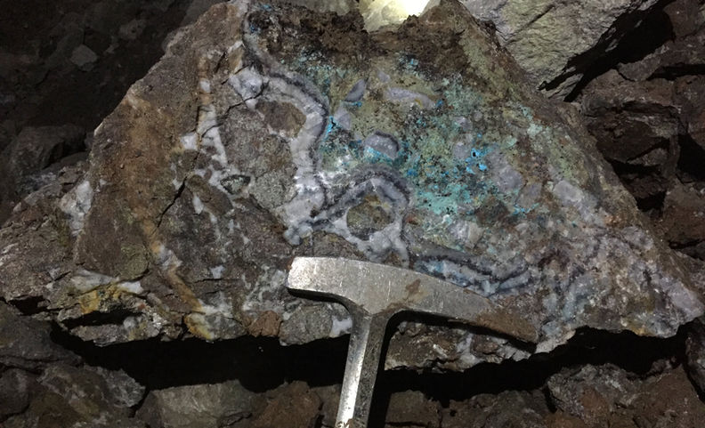
It presents a mineral zone of oxides with low volumes of sulfides. Mineralization is concentrated exclusively in veins formed by an alternation of millimeter bands of crustiform and coloform quartz, together with bands of crystalline barite, carbonates and discrete patches of adularia, the latter also representing the associated gangue (Photo 3 d). The veins in marginal sectors have a breccia appearance, showing moss and cockade-like textures (Photo 3 d, Photo 4 c and d). At the surface level, the recognized ores are mainly copper oxidized such as brocanthite, malachite, azurite and chrysocolla, in concomitance with cerussite, zinc oxide, chenevixite and silver oxide, all occurring in replacement, filling of fractures and impregnations. Coexisting with the previous ones, but exhibiting relatively smaller volumes, remnant traces of chalcosine, pyrite and galena are recognized, arranged in 20 discontinuous guides and isolated subhedral millimeter grains in association with bands of white quartz and gray quartz (Photo 4 b, c and Photo 3 c).
Additionally, a Qemscan analysis carried out on samples extracted from this sector, details the existence of mineral species in variable volumes, such as hemimorphite (zinc silicate), clays with copper, zinc and lead contents, and chlorargyrite. This same study makes it possible to clarify the close association between the mineral species of lead, zinc and copper, as well as their replacement relationship, for example that which occurs between cerussite on galena, copper carbonates on chalcosine and the possible pseudomorphic replacement of hemimorphite by sphalerite
EXPLORATION
In February 2018, HCA initiated an exploration program aimed at evaluating these previously untested areas of prospective polymetallic mineralization. The surface geological work included evaluating the structural and stratigraphic setting of the mineralization was used as a base for exploration drifts design and development.
Moreover, the general location plan of the drilling sections with respect to the traces of the mineralized structures was designed and prepared to be carried out to evaluate 150-300 meters depth ore shots.
The sections with their respective drilling platforms
MINE CONSTRUCTION
In March 2020, the main drift development was started. The drift is built from the 1114 m a.s.l., with a planned section of 3 x 3 m and an average slope of 8%
Mineralogical study of the ore shot at the 100 m depth returned with high grade Silver-Copper mineralization (3% Cu, 350 ppm Ag) with a strong Pb-Zn anomaly.
MAP GALLERY
PHOTO GALLERY
REPORTS
REPORTE VISITA TÉCNICA
MINA CERRO EL PLOMO
PLAN DE RECONOCIMIENTO Y EXPLOTACIÓN
MINA AZUL
Comuna de Monte Patria
Provincia de Limarí
- Enero 2020 -
Levantamiento Geológico-Estructural
Túnel de Exploración
Proyecto El Plomo
Segundo Reporte
ANALISIS MINERALOGICO
BSP-SECCION y AMODAL
24/02/2020
Programa de perforación proyecto El Plomo
ANALISIS MINERALOGICO
BSP-SECCION y AMODAL
24/11/2020
GEOLOGÍA PROSPECTIVA
DEL PROYECTO MINERO EL
PLOMO
Primera etapa
MAPTEC VULCAN 3D MODEL
Project CERRO EL PLOMO WEST
High grade Cu-Ag complementing structure
Cerro el Plomo West structure Exploration and Exploitation Project is the next step of opening it´s resource potential.

OVERVIEW
Located on the western slope of Cerro El Plomo, below 1080 m.a.s.l., it exhibits well located styles of vein-mantle mineralization whose real dimension, extension vertical and lateral continuity has not been established with certainty to date. The structures described have orientation N30E and N55E with angles of 60°-70 ° SE, running from all less than 50 meters and widths that do not exceed one meter. Regarding the mineralized mantles, at least two points have been recognized, 180 meters apart, where show concordant with the general stratification of the sequence with azimuth N20E/15SE.

MINING EVIDENDE
Geological mapping faced with evidence of artisanal mining operations from the past. Thus, few old drifts done through the mineralized outcrops and relevant dumps sectors were discovered. Geochemical and mineralogical studies demonstrate high value Copper-Silver mineralization worth to be explored by systematic exploration drifting.

GEOLOGY
The recognized mineral system of the West Structure presents occurrences and styles of mineralization consistent in a vein-mantle model, controlled due to the reactivity of the hostrock in the sector, which would favor replacement processes and associated mineralization.
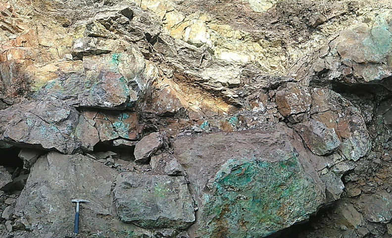
The mineralization of the WEST sector is restricted to mantles of decimetric to metric and bodies of crustiform quartz veins around one meter in thickness. Veins have a yellowish brown color derived from iron oxides of the goethite type and to a lesser jarosite proportion, filling fractures and pseudomorphic replacement of pyrite. Very subordinate volumes of chrysocolla, chenevixite, black copper and brocanthite punctual are appreciated in impregnation and filling of fractures, in concomitance of sulfides such as chalcosine and arsenopyrite. Associated bargains correspond to quartz, calcite and barite very subordinate. The mineralized mantles are associated with an intense quartz replacement process and have significant volumes of copper oxidized relatively higher than the veins. The ores are characterized primarily by a dense latticework of massive millimeter guides of chrysocolla in association with minor contents of black copper, chenevixite and malachite. In some sectors, clusters of massive chalcopyrite stand out with moderate partial replacement of goethite. Additionally traces of oxidized silver are recognized.
There are at least two relevant structural sets in the sector, one related to mineralized veins with courses N30W and N55E, with mantles to the SE, and a second set corresponding to normal N30W / 75SW attitude faults, which have been observed by cutting and displacing, in a vertical direction, mineralized beds and eventually veins.

MINERALIZATION
Most of the occurrence of Copper present in the sample is found as carbonate (Rosasite, Malachite), and 15.2% of the global minerals have copper. Because of the supergenic nature of the sampling, copper sulfides are found in a minor proportion (mainly Calcosine and Enargite). Occurrence of zinc is found as Rosasite (86.3%), Hemimorphite (11.4%), mainly and to lesser extent as Zn Oxides (2.3%). Rosasite ((Cu, Zn) 2CO3 (OH) 2) is a carbonate of Cu and Zn and is formed as a mineral of secondary in Zn-Cu deposits. Hemimorphite (Zn4Si2O7 (OH) 2 · H2O) is a hydrated zinc silicate found in the oxidation zone of zinc and lead sulfides, that is, in the upper part of the mines of Zinc. Which could indicate that at depth there is massive Sphalerite. The analyzed sample does not have any presence of zinc and lead sulfides (Sphalerite and Galena respectively). There is a large amount of Arsenate in the sample (Duftite, Cuproadamite, Olivenite), which they must be studied to see their effect on concentration by flotation.

EXPLORATION

PHOTO GALLERY
REPORTS
Technical Memorándum
Análisis Mineralógico Pique Antiguo
- David Barriga-Metalurgista Senior
ANALISIS MINERALOGICO
BSP-SECCION y AMODAL
24/02/2020
PLAN DE RECONOCIMIENTO Y
EXPLOTACIÓN EL PLOMO OESTE
Project LA PLACETA
Following polymetallic regional scale structure LA CORRIDA DE PLOMO

OVERVIEW
Located 5,5 km strait line to the South from Cerro El Plomo, LA PLACETA is the 6th polymetallic manifestation among the old mines sequence related to the regional structure LA CORRIDA DE PLOMO. Up to January 2021 the property is on the early exploration stage. Archive research, geological prospecting and investigation of the mining evidence (pits, tranches) opened set of four parallel veins N-S orientation 1-1.5 m width with promising polymetallic potential which corresponds to the pattern of the main structure.

La Corrida del Plomo Mapping
Archivo EMPRESA NACIONAL DE MINERÍA, 1948


REPORTS
Assays Sampling HC Americas 21 April 2017
Assays Sampling HC Americas 03 May 2017


